 |
| Great circle route around the world starting from Budapest and passing through China, Oceania and South America |
In
a previous post, I put together an itinerary to go round the world in
thirty-seven days. The itinerary was then successfully implemented
in a virtual world tour lasting from the 8th
April to the 15th
May 2013.
I received some criticism, however, for my very “loose”
interpretation of the notion of going around the world. My world tour
could be considered a circumnavigation of the earth only in one
sense: namely, that I arrived back to my starting point after
crossing every line of longitude of the planet. It did not fulfil two
other criteria that one may expect of a circumnavigation: First, the
length of the route did not add up to the circumference of the earth
(the whole journey covered around 34.000 km as opposed to 40.000 km,
the approximate length of the equator). Second, I came nowhere close
to reaching the antipode, i.e. the exact opposite point of my
starting place at the other side of the earth; in my case, this would
have been in the Southern Pacific, but I did not even leave the
northern hemisphere during my journey.
My biggest excuse for these shortcomings is that I followed a great
example: Phileas Fogg, Verneʼs hero. Mr Fogg cared just as little
with reaching the antipode as myself – although the length of his
journey may incidentally have added up to the circumference of the
earth due to the circuit he had to make around Asia. In any case, all
Fogg had in mind was to come back to London after crossing every line of
longitude within 80 days.
Apparently,
other people were less impressed by Mr Foggʼs achievement: Norris
McWhirter, the founding editor of Guinness World Records went as far
as to include the antipode-requirement in a formal definition of a
“true circumnavigation.” As he formulated it: “a
true
circumnavigation
of the world must pass through two points antipodean to each other”,
i.e.
two
places on the surface of the globe that are diametrically opposite to
each other.
Champions of this definition argue that crossing a pair of antipodal
points means automatically crossing the equator, traveling the
minimum length of the earthʼs circumference, and spending equal time
in both the southern and the northern hemispheres. Obviously, neither
Foggʼs nor my world tour qualify as a “true circumnavigation”,
according to this definition.
Mere
scientific criticism of my world tour could have been dismissed
easily. Scientific criticism that promotes a circumnavigation
“spending equal time in both the southern and the northern
hemispheres”, however, is much harder to dismiss. It has some
inherent psychological appeal. Who would dispute that a journey
through tropical areas and the southern seas is superior to one
through Siberia, Alaska, and Newfoundland? In the end, I found myself
thinking about how to organize a world tour that passes through “two
points antipodean to each other.”
The first discovery I made was that this is not a
single-solution problem: not only can anyone have oneʼs own
tailor-made world tour, but these world tours – even if starting
from the same place – may not have anything in common. In fact,
there is an indefinite number of possible routes – of equal length
– to get from one antipode to the other. Therefore I decided not to
begin with putting together my own itinerary, but with outlining a
couple of simple steps that you should follow if you plan a true
circumnavigation of the world.
First of all, you have to understand the cause of the
inexhaustible variety of world tours. For this purpose, we have to
introduce the concept of “great circles.”
Everything You Always Wanted to Know About Great Circles But Were Afraid to Ask
Everything You Always Wanted to Know About Great Circles But Were Afraid to Ask
A great circle is defined as any circle drawn on the surface of the globe with its center coinciding with the center of the globe. Thus, the diameter of a great circle is the same as the globeʼs and the great circle divides the globe into two equal halves. Notable great circles of the earth are the equator and every meridian.
An
important characteristic of great circles is that they represent
the shortest distance on the globeʼs surface between any two points
their segments connect. This is because great circles have the
largest radius among curves that can be drawn on the globeʼs
surface. The larger a curveʼs radius, the closer it is to a straight
line – which is the shortest distance between two given points.
Therefore the segment of the great circle falling between the two
given points represents the shortest distance between the two points
on the globeʼs surface.
Because
of this, great circles have been important in navigation for hundreds
of years. They are
still used in long distance travel as the most efficient way to move
across the globe – at least where wind and water currents do not
play a significant role. In the northern hemisphere, for example,
airplanes traveling west normally follow a great circle route over
the Arctic – whereas they use the rapid eastward airflow of the jet
stream when traveling eastbound.
 |
| Great circles transform to straight lines via gnomonic projection. Credit: Marozols |
 |
This gnomonic map, centered on the North Pole, was plotted by American cartographer Richard Edes Harrison in 1943 in order to raise the awareness of the American public for the proximity of the US to Germany and to the Soviet Union through great circle routes over the Arctic. (Publisher: Time, Inc., downloaded from the Norman B. Leventhal Map Center.) Harrison connected some cities with straight lines, indicating the shortest route between them. I drew straight lines myself from Budapest to Manila (with red) and to Panama (with yellow) showing the great circle routes leading to these places.
|
The gnomonic map in itself is unsuitable for navigation, however. One reason for this is that the gnomonic projection can depict less than a hemisphere of the globe on a single map: even the edge of the depicted hemisphere lies in infinity. Accordingly, regions close to the edge are extremely distorted both in shape and in areas. The other, more important reason is that the course to follow is difficult to determine based on a gnomonic map. For centuries, people used the compass to define the direction they should be heading to reach their destination. On a great circle route, however, the compass direction (the course to follow as compared to north) will continually change (the route will cross meridians at a continuously changing angle). While it is possible to get an idea of this changing compass direction by looking at the gnomonic map, it is by far not the most suitable way of determining the actual course to follow. There is a much better solution: it is called the Mercator projection.
The Mercator projection was
designed by the Flemish cartographer Gerardus Mercator in 1569
precisely for navigation purposes. It has the unique feature of
representing routes of constant compass direction as straight lines.
This is achieved by two important characteristics of the projection:
First, it depicts the globe as a rectangular coordinate-system with
an east-west and a north-south axis, in which every meridian makes a
right angle with every line of latitude. This characteristic, which
is common to all normal cylindrical projections, suits the frame of
reference of a compass. Second, the Mercator-projection stretches
latitudes (north-south distances) in the same proportion as it
stretches longitudes (east-west distances). The east-west stretching
of distances away from the equator follows necessarily from the
characteristic of normal cylindrical projections that they represent
all lines of latitude as having the same length – although these in
fact become ever shorter approaching the poles. By applying the same
stretching also to north-south distances, the Mercator-projection
provides conformality (the preservation of angles) at the expense of
the equality of areas – which become extremely distorted at higher
latitudes.
As a consequence of conformality,
a straight line drawn on the Mercator-map between two points will
show the direction in which the two points are located as compared to north. The line defined by this “true compass direction” will
make the same angle with every meridian it crosses. If you follow
this route, therefore, the compass direction will be constant
throughout the journey. Since you need not regularly adjust the
course, navigation is much easier.
Of course, the route defined by constant compass direction will in
most cases be different, and therefore longer, than the great circle
route. At longer distances and on higher latitudes, the difference
between the two routes may be significant both in path and in length.
 |
| Routes from Budapest to Manila on a Mercator-map. The red line shows the great circle route (also called "orthodrome") taken manually from the gnomonic map above. The blue line represents the constant course route (also called "loxodrome"). |
It is possible, however, to plot the great circle route
on a Mercator-map. In this case you will have the best of both
worlds: the shortest route – depicted in a way that shows how the
course is changing along it. Such a mapping can be achieved by taking
the great circle line drawn on the gnomonic map, noting a number of
points along it (e.g., where it crosses a shoreline, a river or a
meridian), then plotting the same points on the Mercator map and
connecting them with a smooth curve. Please note that the resulting
line will appear curved on the Mercator map and will therefore look
longer than the straight line between the same points (representing
the constant course route). In reality, the great circle route
(represented by the curved line) is the shorter.
All roads lead to the antipode
In contrast to this, an indefinite number of great
circle routes exist that lead to a starting pointʼs antipode. This
truth can best be visualized on the example of the poles. Obviously,
you can get from the North Pole to the South Pole by following any
meridian – and every meridian is a great circle with the same
length. Between other antipodal points you can similarly draw great
circle routes through any arbitrarily selected third point on the
surface of the globe. The reason for this is simple: Any great circle
drawn from a given starting point has to pass through the pointʼs
antipode, that is, where the globeʼs diameter drawn through the
starting point intersects the other side of the globe. Otherwise it
would not be a great circle.
 |
You can check this thesis with the help of modern
technology. Today you no longer need a gnomonic map to find the great
circle route between two places: you can use a great circle mapping software instead. With such a software you can also conduct the
following experiment: Enter two antipodal points as the start and end
points of the route and any third point as an
intermediate station.
Let the software draw the great circle route between the given
points. When looking at the result you will notice two things: First,
that the line of the route is not broken at the intermediate station
– suggesting that the intermediate point lies on the great circle segment connecting the start and end points. Second, that the length of the
route is about half of the
circumference of the Earth – suggesting,
again, that the line drawn between the antipodal points is half of a
great circle. Now repeat the above steps with different intermediate
stations. The results will be similar: smooth curves through the
intermediate stations with a length of half of the Earthʼs
circumference. All the lines drawn this way will be great circle
segments connecting the
two antipodal points through the arbitrarily
selected intermediate station. This proves that there is an
indefinite number of great circle routes leading to a pointʼs
antipode.
 |
 |
 |
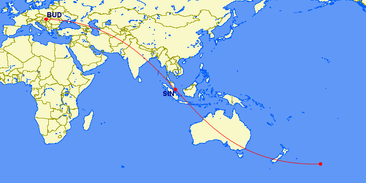
From Budapest, for example, you can draw great circle
routes via Helsinki, Vladivostok, Singapore, Nairobi, Rio de Janeiro,
Lima, or Chicago, all
leading to the cityʼs antipode. The length of
these routes vary from 20 005 km to 20 020 km, i.e. around the half
of the earthʼs circumference (the routes passing through the polar
regions being somewhat shorter because the earth is flattened along
the axis). In contrast, the constant course route between Budapest
and its antipode would be 20564 km long, i.e. around 560 km longer
than
any great circle route. The difference is not very big because
the constant course route goes mostly through low latitudes, where
its frame of reference is consisted of lines of latitude and
longitude that are either great circles themselves or are pretty
close to it.
 |
 |
| Great circle routes from Budapest to its antipode through Helsinki, Vladivostok, Singapore, Nairobi, Rio de Janeiro and Chicago |
After this short introduction into the theory of great
circles, the steps of planning the route of a true circumnavigation
are pretty straightforward.
Step 1 : Choose the pair of antipodal points you would like to
pass through
A
bit counterintuitively, the antipodes do not necessarily have to
include your starting point: What matters is that you pass through a
pair of antipodal points along the way, no matter where they are
located on the route. It is
practical, however, to have both antipodes on land and not on sea
because it is difficult for an ordinary person to get to a certain
place on sea if he or she does not own a ship. In effect, this
imposes serious restriction on the available set of antipode-pairs:
as 71% of the earthʼs surface is covered by sea, it is not easy to
find two places exactly opposite to each other that are both on land.
You can try on the following webpage:
http://www.findlatitudeandlongitude.com/antipode-map.
As you will see, possible pairs of antipodes include: the South
Sahara in Mali – the Fiji Islands on the Pacific; Rajasthan
province, India – Easter Island; Buryatia, Russia – Tierra
del Fuego, South America; Beijing
– Rio Negro province, Argentina; Singapore – East Ecuador;
Montana, U.S. – the Kerguelen Islands on the Southern Indian Ocean.
Europe almost completely lacks any antipodal points situated on land
– the exception being the Iberian Peninsula, which has antipodes on
New Zealand. If you start from Europe and want to get to the other
side of the earth, I recommend a pair of antipodes formed by the
Sevilla region, Spain – and Auckland, New Zealand. If getting to the
other side of the planet is not important to you, on the other hand,
you can find a wide choice of comfortably located antipode-pairs on
the Far East – South America axis.
Step 2: Choose the region through which you would like to get from
one antipode to the other
As the location of the antipodes does not determine the route in any
significant way, this is really a choice up to you. You may prefer
the most exotic regions or fast transport networks or you may want to
see as much on the way as you can. You can then draw a great circle
route between the two antipodes through the selected region as
intermediate station.
Assume, for example, that the antipodes you selected are Sevilla and
Auckland. You can take a rather exotic route through the Arabian Peninsula. Or you may like the idea that you can get from Europe to China pretty fast by train. Or you may be bent on making most of the
journey on land and therefore decide to go through India. For
each of these selections, you can draw the great circle route, which
will show you the shortest way from Sevilla to Auckland through the
chosen region. You may even make your final decision concerning the
direction after comparing these routes.
You can repeat the same exercise for the return journey on the other
hemisphere.
Step 3: Prepare the detailed
itinerary based on the great circle route
Of course, the great circle route
drawn this way represents only an “ideal” way to get from one
antipode to the other. You will need to deviate from this route to
some extent depending on the available transport options. This
“practical” side of planning a true circumnavigation will be
discussed on the example of my own “antipodean” world tour to be
presented in a later post.


No comments:
Post a Comment